Civilian emergency infrastructure fails when concurrent, fast-moving environmental crises deplete localized suppression assets. In Minnesota, the outbreak of the Flanders Fire in Crow Wing County and the Stewart Trail Fire near Two Harbors triggered an immediate operational deficit. This deficit forced the execution of a peacetime emergency declaration by Governor Tim Walz, activating the Minnesota National Guard. While media narratives frame these interventions as simple reinforcements, a technical analysis reveals that military mobilization serves a precise logistical function: bridging the critical gap between localized containment capacity and rapid, weather-driven rate of spread (ROS).
To evaluate the efficiency of this mobilization, the crisis must be deconstructed into its component variables: fuel conditions, rate of consumption, structural exposure, and tactical asset distribution.
The Core Triad of Wildfire Acceleration
The sudden expansion of the northern Minnesota fires is dictated by three compounding environmental vectors: fuel moisture metrics, atmospheric volatility, and human ignition variables. The Minnesota Interagency Fire Center confirmed that Red Flag Warning conditions acted as the primary catalyst, transforming standing biomass into highly combustible fuel.
- Fuel Moisture Depletion: Prolonged dry conditions in early spring reduce the moisture content of 1-hour and 10-hour fuels (dead surface vegetation, twigs, and leaf litter). When fuel moisture drops below critical thresholds, the energy required for ignition drops logarithmically, allowing minor sparks to achieve sustained combustion.
- Atmospheric Wind Coupling: High sustained winds and erratic gusts maximize the rate of spread by tilting the convection column. This mechanism leans the flame front forward, preheating unburned fuels through radiation and convection before physical contact. Wind also drives "spotting"—the lofting of burning embers ahead of the main fire front, bypassing natural and artificial containment lines.
- Ignition Density: In adjacent St. Louis County, local law enforcement identified 17 distinct wildfire outbreaks in a single 24-hour period, primarily initiated by unauthorized civilian debris burning. High ignition density fragments local fire department resources, preventing the consolidation of forces on any single front.
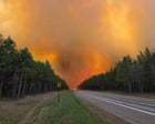
This combination created a compounding operational bottleneck. By Sunday morning, the Flanders Fire had expanded to approximately 1,200 acres (with later estimates climbing toward 2,100 acres) at 0% containment. Simultaneously, the Stewart Trail Fire consumed 355 acres, demonstrating a high structural-destruction-to-acreage ratio.
Resource Allocation and the Logistic Constraint
Every wildfire response operates under a strict resource allocation framework. Local municipal fire departments are designed for structural protection and low-acreage containment. When a wildland fire enters an exponential growth phase, local assets hit an absolute ceiling in equipment and personnel endurance.
The Tactical Deficit Matrix
The operational gap that triggered the National Guard deployment is defined by three distinct resource shortages:
- Heavy Line-Construction Capacity: Containing a 1,200-acre fire requires thousands of feet of continuous fireline. Hand crews utilizing manual tools face a strict physical limit on linear feet cleared per hour. While the Minnesota Department of Natural Resources (DNR) deployed bulldozers and tracked vehicles to cut lines between Flanders Lake and the Pine River, the sheer perimeter expansion outpaced mechanical line creation.
- Sustained Aerial Suppression: Air tankers and water-dropping helicopters provide critical cooling effects to slow the flame front, allowing ground crews to work safely near the perimeter. However, aerial assets are strictly bound by turn-around times (the duration required to fly to a water source, scoop or fill, return, and drop).
- Perimeter Security and Evacuation Staffing: Managing a large-scale fire requires significant manpower diverted away from the actual fireline. Securing road closures (such as State Highway 61 between Two Harbors and Silver Bay, and County Road 11) and executing mandatory evacuations requires hundreds of security personnel.
The National Guard’s entry alters this equation. Guard activation does not merely add raw numbers; it introduces heavy machinery, specialized aviation units (such as UH-60 Blackhawk helicopters equipped with Bambi Buckets), and disciplined, self-sustaining logistical units that operate independently of local municipal supply chains.
Structural Exposure Metrics and Incident Architecture
The tactical priority of any incident command structure follows a strict hierarchy: life safety, incident stabilization, and property conservation. The Stewart Trail Fire near Two Harbors highlights the extreme risk encountered when a wildland fire interfaces with rural residential developments.
Preliminary damage assessments from Lake County Sheriff Nathan Stadler revealed a stark contrast between the two main fires:
| Variable | Flanders Fire (Crow Wing County) | Stewart Trail Fire (Lake County) |
|---|---|---|
| Estimated Footprint | 1,200 – 2,100 Acres | 355 Acres |
| Containment Metric | 0% | 30% |
| Total Structures Destroyed | Minimal/Secondary Only | 34 Structures |
| Primary Residential Losses | 0 | 8 |
| Secondary/Utility Losses | Minor (Outbuildings/Sheds) | 26 |
The Stewart Trail Fire demonstrates that acreage is a poor proxy for economic and societal impact. Despite being significantly smaller than the Flanders Fire, its higher density of structural fuel loading (homes, outbuildings, vehicles) presented a much more severe risk profile.
When a fire enters a residential zone, the tactical calculus shifts from wildland suppression to defensive structural triage. Firefighters must evaluate which structures are defensible based on surrounding fuel clearance (defensible space) and weather conditions. Structures that require excessive resources to protect are abandoned to preserve assets for broader containment efforts. The destruction of 34 structures indicates that the Stewart Trail Fire experienced a high-intensity thermal surge that overwhelmed initial defensive positioning.
The Airspace Conflict: Drone-Induced Containment Failures
A critical vulnerability in modern incident command architecture is the interference of civilian technology with aerial suppression assets. During the weekend operations, state authorities were forced to implement a Temporary Flight Restriction (TFR) over the active zones, explicitly warning civilians to ground all Unmanned Aerial Vehicles (UAVs) or drones.
The operational consequence of a single civilian drone in a TFR zone is absolute: all aerial firefighting assets are grounded immediately. Water-dropping planes and helicopters operate at low altitudes—often between 100 and 300 feet above the canopy—under conditions of severely degraded visibility due to smoke. The collision risk between a 30-pound low-altitude aerial asset and a civilian drone is catastrophic to the aircraft's propulsion and rotor systems.
When aircraft are grounded due to a drone intrusion, the fire experience an unmonitored, unsuppressed acceleration phase. Ground crews lose their primary cooling support, often forcing them to retreat from established lines, invalidating hours of bulldozer and hand-line construction.
Strategic Forecast and Deployment Vulnerabilities
The peacetime emergency declaration signed by Governor Walz is legally bounded to expire on June 7, 2026, or whenever emergency conditions subside. This finite window requires a highly optimized deployment timeline. National Guard integration into the Minnesota Incident Command System (MNICS) must navigate clear operational friction points over the next 72 to 96 hours.
The primary vulnerability is changing wind patterns. While initial containment lines for the Flanders Fire were successfully established by bulldozers on the northern and southern flanks, a shifting wind toward the east alters the directional vector of the fire head. Lines that were once secure flanks can instantly become the new front of the fire, rendering previous containment loops obsolete.
Furthermore, military personnel integrated into civilian wildland firefighting operations require tight command coupling. The National Guard operates under a rigid hierarchical chain of command, whereas wildland fire tactics rely on highly fluid, decentralized decision-making at the strike-team level. If communication protocols between the MNICS incident commanders and Guard asset leaders experience technical or procedural latency, tactical deployment efficiency drops.
The critical path to achieving containment over the next 48 hours requires the immediate deployment of Guard heavy aviation assets to the Flanders Fire to suppress spot fires across the Pine River, while consolidating ground-based Guard security forces along Highway 61 to allow Lake County crews to focus exclusively on structural defense and line tying. Suppression teams must prioritize securing the windward flanks before afternoon thermal heating cycles accelerate the rate of spread.