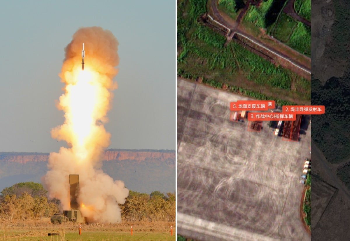
A Chinese artificial intelligence startup has stripped away the camouflage of America's most sensitive regional deployment, publishing high-resolution satellite images of the US Army's Typhon missile system stationed in southwestern Japan. The leak, orchestrated by Hangzhou-based geospatial firm MizarVision, exposes the precise locations of the highly classified launcher units during joint military exercises. This development shatters the Pentagon's assumption that mobile missile batteries can remain hidden along the First Island Chain, signaling a fundamental shift in how modern wars will be tracked, targeted, and fought.
The images, shared widely across Chinese social platforms and international defense networks, show the Typhon system parked near military infrastructure. These are not grainy, indistinct shapes. The analysis outlines the distinct silhouette of the transporter erector launchers, the command vehicles, and the support trailers that make up a complete Mid-Range Capability battery.
By rendering these assets visible almost in real-time, Beijing has sent a chilling message to Washington and Tokyo. The era of operational surprise in the Pacific is officially over.
A High Resolution Trap
To understand why these satellite images have sent shockwaves through the defense establishment, one must understand how MizarVision operates. The company does not own a massive fleet of military spy satellites. It does not need to.
Instead, the firm purchases ordinary commercial satellite imagery from global providers. This is the same imagery used by agricultural companies, urban planners, and environmental researchers. The true power lies in the proprietary artificial intelligence models MizarVision overlays onto this data.
These neural networks are trained to identify military hardware automatically. Within hours of an image being captured, the software scans thousands of square kilometers of terrain, flags anomalous shapes, and matches them against a massive database of military vehicles. The AI can immediately distinguish a standard commercial cargo container from a Typhon launcher, even when covered in camouflage netting.
This is the democratization of geospatial intelligence. What once required the multi-billion-dollar apparatus of a national intelligence agency is now being accomplished by a lean startup with fewer than two hundred employees. They are turning a flood of raw, public data into finished, actionable targeting packages at a fraction of the cost.
Why the Typhon Matters
The Typhon system is not just another piece of artillery. It is the center of gravity for the US military's strategy to deter a Chinese invasion of Taiwan.
Historically, the US Army was banned from possessing ground-launched missiles with ranges between 500 and 5,500 kilometers under the Intermediate-Range Nuclear Forces Treaty. When that treaty collapsed, the Pentagon rushed to fill the gap. The result was Typhon, a highly adaptable land-based launcher that fires modified Navy Standard SM-6 and Tomahawk cruise missiles.
Typhon System Range Capabilities:
+-------------------------------------------------------+
| SM-6 Missile: ~370 km (Anti-Ship & Air Defense)      |
+-------------------------------------------------------+
| Tomahawk Cruise Missile: ~1,500+ km (Land Attack)     |
+-------------------------------------------------------+
When deployed in southwestern Japan, Typhon's Tomahawks can reach deep into the Chinese mainland, putting critical industrial hubs like Shanghai directly in range. More importantly, its SM-6 missiles can target Chinese warships attempting to transit the Miyako Strait, a vital naval chokepoint that the People's Liberation Army Navy must pass through to access the open Pacific.
By placing Typhon in Japan, the US and its allies are attempting to build a steel ring around China's maritime exits. But a weapon system is only effective if it survives long enough to fire.
The Death of Hide and Shoot
The US Army's operational doctrine for regional conflicts relies heavily on a concept known as "expeditionary advanced base operations." The theory is simple. Small, highly mobile units disperse across remote islands. They setup, fire a volley of precision missiles at enemy ships, and immediately pack up and move before the enemy can locate and strike them.
This "hide, shoot, and scoot" strategy is the cornerstone of modern defensive planning in the Pacific.
MizarVision's latest intelligence release reveals this strategy to be a dangerous illusion. A land-based missile launcher is, fundamentally, a massive logistics footprint. It requires heavy prime movers, generator trucks, satellite communication dishes, and security personnel.
- The Footprint: A single Typhon battery consists of four large launchers and a mobile command center.
- The Transit: These systems must be transported via heavy cargo aircraft, like C-17s, or roll-on/roll-off shipping vessels.
- The Signature: This leaves a massive visual trail at local airfields and ports, which AI models can easily flag.
Even if the launchers are moved into the dense forests of Kagoshima or tucked away in hardened hangars, they must eventually emerge to train or deploy. The relentless revisit rate of modern commercial satellite constellations means that a launcher is likely photographed multiple times a day. The AI simply connects the dots, tracking the system's movements along Japanese highways and identifying its final firing positions.
The Gray Zone Weaponization of Commercial Space
The timing of MizarVision's publication is no accident. The firm has a history of releasing detailed intelligence on US forces precisely when geopolitical tensions spike.
In early 2026, during heightened friction in the Middle East, MizarVision published automated tracking data that exposed US F-22 stealth fighters and THAAD air defense batteries deployed across Jordan and Saudi Arabia. The US Department of State eventually sanctioned the company, accusing it of providing de facto proxy intelligence that helped hostile forces plan precision drone and missile strikes.
Yet, sanctions have done little to slow the company down. Because MizarVision operates within China and draws much of its raw data from domestic commercial constellations—such as the massive Jilin-1 network—it remains entirely insulated from Western legal pressure.
This setup provides Beijing with perfect plausible deniability. If the Chinese military published these images, it would be seen as a direct escalation. When a "private" commercial AI firm does it, the activity is framed as open-source academic research. Yet, the tactical utility of the data to the People's Liberation Army Rocket Force is identical.
Re-evaluating the First Island Chain
For decades, the United States has relied on technological superiority and operational secrecy to maintain its dominance in the Western Pacific. The assumption was that the sheer vastness of the ocean, combined with advanced stealth and electronic warfare, would allow American forces to operate with a high degree of impunity.
That assumption is dead.
The tracking of the Typhon system in Japan proves that the First Island Chain has become highly transparent. Camouflage netting, decoy launchers, and night movements are no longer sufficient to evade an adversary that has automated the analysis of the sky.
If the US and Japan continue to rely on static or slow-moving land-based missile batteries to deter conflict, they are placing their forces in a highly vulnerable position. In a high-end conflict, the locations exposed by commercial AI today will become the coordinates for precision ballistic missile strikes tomorrow. The Pentagon must either adapt its survival tactics to an era of total visibility, or accept that its forward-deployed shields are already painted with targets.