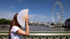
Britain is on the verge of its annual meteorological hallucination. tabloid headlines are broadcasting a 30C mega-heatwave arriving just in time for the late May bank holiday weekend. Millions of people are adjusting their plans, booking coastal getaways, and buying disposable barbecues under the assumption that summer has arrived ahead of schedule.
The reality on the ground is far more precarious. While an influx of warm air from mainland Europe will trigger the hottest days of the year so far, hitting an official heatwave threshold or breaching the 30C mark remains a statistical longshot. Met Office modeling shows peak temperatures in the south and southeast are much more likely to hover around 26C to 28C, with a high risk of thundery downpours and low pressure breaking the spell before the long weekend concludes.
The Anatomy of Weather Hyperbole
The disconnect between public expectation and atmospheric physics stems from how meteorological data is translated for public consumption. Every spring, a predictable cycle occurs where a single, outlier run of a long-range weather model is plucked by betting syndicates and sensationalist outlets to generate dramatic headlines.
Bookmakers have cut odds to 6/4 that temperatures will exceed 30C on Monday, May 25. This creates an illusion of certainty. In reality, a temperature of 30C in May is historically rare in the UK. The last time the country recorded a temperature above that threshold in May was in 2012, when Inverailort in the Scottish Highlands reached 30.9C.
To understand why the 30C claim is shaky, one must look at the actual mechanics of the incoming weather system. High pressure is building from the south, shifting the stubborn Arctic currents that made the first half of May feel unseasonably chilly. This will indeed draw up warm, humid air. However, a slow-moving low-pressure system remains parked to the west of the UK. This creates a battleground over the British Isles where intense solar heating meets unstable moisture.
Why a Technical Heatwave is Unlikely
The term "heatwave" is not a vibe. It is a precise mathematical definition. For the Met Office to officially declare a heatwave, a specific location must record three consecutive days where the daily maximum temperature meets or exceeds a regional threshold.
+--------------------------+---------------------+
| Region                   | Heatwave Threshold  |
+--------------------------+---------------------+
| London & Southeast       | 28C                 |
| East & Midlands          | 27C                 |
| Southwest & North Eng.   | 25C                 |
| Scotland & N. Ireland    | 25C                 |
+--------------------------+---------------------+
While London and parts of Cambridgeshire may see the mercury spike to 28C on Friday, maintaining that level across Saturday, Sunday, and Monday is unlikely. Forecasters are tracking an upper trough that threatens to introduce cloud cover and heavy, localized showers by Friday night. Once cloud cover rolls in, the ground loses the direct solar radiation required to push ambient air temperatures into the high twenties.
Furthermore, the national picture is starkly divided. While the southeast bakes in humid air that makes it feel hotter than Athens or Ibiza, northwestern Scotland and Northern Ireland will remain under a blanket of cloud with regular outbreaks of rain. Labeling this a nationwide heatwave distorts the reality of a highly localized, transient warm spell.
The Human and Infrastructure Cost of Sudden Spikes
The rush to celebrate early summer heat often obscures the logistical friction it creates. Because Britain spent the first three weeks of May shivering in single-digit night temperatures, the sudden transition to high humidity and mid-20C warmth catches infrastructure and individuals unprepared.
- The Grid and Water Pressure: Sudden coastal migrations cause localized water pressure drops as thousands hit beach towns simultaneously.
- The Transport Flaw: Rail networks optimized for cool, damp climates face track buckle risks when ambient temperatures spike rapidly before seasonal maintenance is fully completed.
- The Health Shock: High humidity paired with sudden UV index jumps caught early-season sunbakers off guard, leading to an inevitable surge in emergency admissions for heat exhaustion.
The weekend will undoubtedly offer fine, pleasant windows for outdoor activities, particularly on Sunday when high pressure asserts more dominant control over the southern half of England. But treating a standard late-spring warm front as an unprecedented tropical event misleads consumers and leaves businesses vulnerable to sudden weather shifts.
The incoming air mass is a welcome reprieve from a miserable spring, but it is not a tropical summer. Pack the sunscreen, but keep an umbrella within arm's reach.